| e-mail: contact@masw.com |


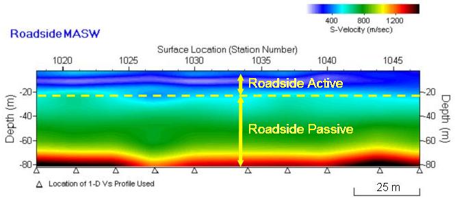
Fig. 1. Utility of passive dispersion image (top) when combined with
the active image (middle) to enlarge frequency (wavelength) range.
the active image (middle) to enlarge frequency (wavelength) range.
Fig. 2. Seismic source characteristics defining active and passive surveys.
| | | | | | | | |
Passive MASW Methods
Passive Remote MASW Passive Roadside MASW Passive and Active Combined Survey Dispersion Analysis for Passive Method
As the surface-wave method gained in credibility and more diverse applications were attempted, demand for a deeper investigation has been also growing, motivating the
utilization of surface waves passively generated by natural and cultural activities (Asten, 1978; Louie, 2001; Suzki and Hayashi, 2003; Park et al., 2004; Yoon and Rix, 2004;
Asten, 2006). While the active survey provides a dispersion curve in a relatively high frequency (short wavelength) range (15-50 Hz, for example, corresponding to wavelengths
of 1-30 m), the passive survey can fill the dispersion trend at lower frequencies (long wavelengths) (5-15 Hz, for example, corresponding to wavelengths of 30-100 m) (Fig. 1).
Whether a survey is active or passive depends on the ability to control three characteristics of the seismic source: (1) excitation time, (2) location (azimuth and distance) relative
to the receiver array, and (3) impact power. When these are all strictly controlled, then it is an active survey; otherwise, it is a passive survey (Fig. 2). For example, hitting on a
plate located 10-m away inline from the 1st channel location by using a 20-lb sledgehammer with a hammer switch attached will be an active survey. In this case, the hammer
switch determines the exact time (1) of the wave generation, and the location of the impact plate and the weight of the hammer head determine the source location (2) and
impact power (3), respectively. On the other hand, none of these three characteristics are controllable when a passive survey records ambient noise without knowing about
them. In specific cases, a passive survey can have partial control when one or more of the characteristics are known to a certain extent. A roadside passive survey is such an
example because the type of impact (moving cars) and incoming angle (azimuth) of surface waves are roughly known.
Okada (2003) reported passive surface waves of frequencies lower than 1 Hz are generally associated with ocean tidal activity of the earth, whereas those immediately above
1 Hz are usually associated with the atmospheric pressure change. Surface waves of the higher frequencies (e.g., ≥ 3 Hz) are attributed to the human activities. Recent
multichannel applications of passive surface waves reported the utilization of mostly traffic-generated surface waves that were recorded with the lowest-frequency geophones
easily available for seismic exploration (4.5 Hz). Because of this availability, frequency range of the surface waves studied has been usually above 5 Hz (e.g., 5-20 Hz).
Frequencies lower than 5 Hz of obvious traffic origin have not yet been reported.
In comparison to the active survey method, the passive method differs in data acquisition and in the subsequent dispersion analysis. After proper dispersion curve(s) is (are)
obtained, the remaining procedure to find the layered shear-velocity (Vs) model is the same as in the active method. Because of the unknown location (azimuth and distance)
of the contributing source points, a two-dimensional (2-D) receiver array—such as a circle or a cross— has to be used so that the subsequent dispersion analysis can handle
the issue of location properly. Recently, as more urban applications arise, approaches using the conventional 1-D linear receiver array are emerging because securing a
spacious area to deploy a 2-D array can be a problem. With these 1-D approaches, receivers are conveniently deployed along the sidewalk, shoulder, and median of a road.
A 2-D Vs mapping can also be done by continuously moving the array. Accuracy of the dispersion analysis with these approaches, however, can become an issue depending
on the handling of offline propagations arriving in oblique angles.
Although this type of passive surface wave application had been studied a half-century ago in Japan—it was called the Microtremor Survey Method (MSM) (Aki, 1957)—it was
not well known among relevant com¬munities in Western countries until quite recently, with the exception of a few study groups (Asten, 1978; Asten and Henstridge, 1984). An
excellent review of the MSM can be found in Okada (2003). Using the frequency-wavenumber (f-k) method, Asten and Henstridge (1984) processed microseisms recorded
with seven seismometers deployed along a cross-layout configuration in a nonlinear fashion over several kilometers of distance. Recently, several research groups
attempted to apply MSM to near-surface investigation (down to10's-100's meters) by using conventional exploration seismic instruments (Haruhiko and Hayashi, 2003; Yoon
and Rix, 2004). Louie (2001) developed a scheme to process passive surface waves recorded with a 1-D receiver array commonly used for a conventional body-wave (e.g.,
refraction) survey. Park et al. (2004) introduced an imaging method for dispersion analysis based on a 2-D receiver array. After identifying the weakness of the 1-D approach
by Louie (2001), Park and Miller (2008) introduced a roadside method using the 1-D receiver array. Park et al. (2005) introduced an effective way of combining active and
passive dispersion images for a more accurate modal identification, implying that modal identity of passive surface waves may not always be the fundamental mode.